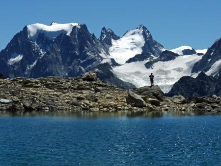
West Fork of Oak Creek
On the third day of our camping trip on the Mogollon Rim above Sedona, we headed to the western end of West Fork. The canyon starts on the Rim, intersecting Woody Mountain Road, and cuts east, where it joins Oak Creek Canyon, a total distance of seven or eight miles. At the Oak Creek end, there’s an official trailhead (West Fork #108) at Call o’ the Canyon, which runs about three miles up the canyon. We decided to try hiking the canyon from the western end, where there’s no official trail… as a matter of fact, there’s a lovely Forest Service sign explaining that there’s no official trail there, you’re pretty much on your own, watch out for flash floods, and please don’t die.
From the bridge, there’s a well worn path that runs for perhaps 0.5 to 0.75 mile along the banks of the creek. Eventually, the canyon becomes too narrow, and walking on the banks is not possible, and it becomes a boulder hop down the creek bed. Fallen trees and very large boulders make the route a bit challenging. At this point, while the canyon is very pretty, it’s not family friendly or very dog friendly (we had to give ours quite a bit of assistance). Given the amount of scrambling, I don’t think this would be a very fun backpacking trail, but with an early start, I believe this could be easily done as a shuttle hike.
Trip report
All photos from this hike
Download and utilize this beautiful high-resolution image titled West Fork of Oak Creek. This visual composition is an excellent choice for developers, bloggers, and content editors looking to add clean aesthetics to their digital layouts. This visual is closely associated with arizona, canyon, creek and flagstaff themes, making it easy to integrate into matching design concepts. The crisp details and professional execution of this west fork of oak creek make it a highly versatile background, hero image, or design element.
Whether you are illustrating an educational article, building an interactive mobile app, or designing engaging social media graphics, high-impact visuals are critical for maintaining user interest and lower bounce rates. This high-definition asset was captured using a professional PENTAX PENTAX K20D camera at ISO 100, with an aperture of f/5.6, ensuring excellent color reproduction and sharpness. Sourcing royalty-free graphics directly from Jooinn allows you to significantly reduce design overhead while maintaining professional-grade quality in your public-facing projects.
Licensing and Terms of Use: This file is released under the Creative Commons CC0 (Public Domain) license. The photographer has dedicated this work to the public domain to the maximum extent allowed by law. You can copy, modify, distribute, and perform the work, even for commercial purposes, completely free of charge, with no attribution required.