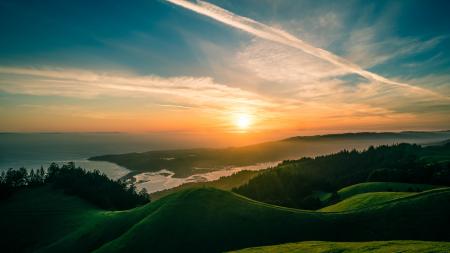
The second largest of the southern glacial lakes, Lake Wakatipu is 48 miles long and up to 3 miles wide, and covers an area of 113 sq. miles. The lake is 1,017 ft above sea level, is 1,239 ft deep, and occupies a single elongated glacial trench having a gently sloping flat floor (probably due to a fill of fine sediments). In contrast to Lake Te Anau, Wakatipu has a more barren appearance because of the lack of forest throughout most of its 1,150 sq. miles of drainage area. It is bordered on all sides by glaciated mountains, the highest of which is Mount Earnslaw near the head of the lake.
Lake Wakatipu. NZ

Lake wakatipu. nz free stock photo
Download and utilize this beautiful high-resolution image titled Lake Wakatipu. NZ. This visual composition is an excellent choice for developers, bloggers, and content editors looking to add clean aesthetics to their digital layouts. This visual is closely associated with cloud, free photos, fz1000 and geo tagged themes, making it easy to integrate into matching design concepts. The crisp details and professional execution of this lake wakatipu. nz make it a highly versatile background, hero image, or design element.
Whether you are illustrating an educational article, building an interactive mobile app, or designing engaging social media graphics, high-impact visuals are critical for maintaining user interest and lower bounce rates. Sourcing royalty-free graphics directly from Jooinn allows you to significantly reduce design overhead while maintaining professional-grade quality in your public-facing projects.
Licensing and Terms of Use: This file is released under the Creative Commons CC0 (Public Domain) license. The photographer has dedicated this work to the public domain to the maximum extent allowed by law. You can copy, modify, distribute, and perform the work, even for commercial purposes, completely free of charge, with no attribution required.
More free photos / by Flickr (Public Domain)